Geolocate

Teling topographic map

Click on the map to display elevation.

About this map

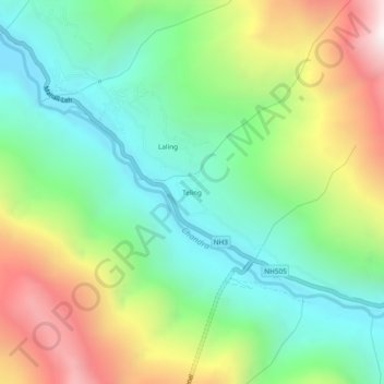
Name: Teling topographic map, elevation, terrain.

Location: Teling, Lahul, Lahul and Spiti, Himachal Pradesh, India (32.42815 77.13941 32.46815 77.17941)

Average elevation: 3,527 m

Minimum elevation: 3,016 m

Maximum elevation: 4,451 m

Other topographic maps

Click on a map to view its topography, its elevation and its terrain.

Chandratal Lake

India > Himachal Pradesh > Lahul

Average elevation: 4,403 m

Suraj Tal

India > Himachal Pradesh > Lahul

Average elevation: 5,007 m

Chandratal Lake

India > Himachal Pradesh > Lahul

Average elevation: 4,403 m

Gear up for your next adventure:

🧥Fleece Jacket - Warm and lightweight jacket for layering
🧥Packable Rain Jacket - Breathable waterproof layer for unpredictable weather
🦶Hiking Shoe Insoles - Added support for high arches and long days on feet
🚲MTB Frame Bag - Carry tools and maps directly on your bicycle frame
🩹Compact First Aid Kit - Pre-packed essentials for common trail injuries

As an Amazon Associate, this site earns from qualifying purchases at no extra cost to you.