Geolocate

Calinan topographic map

Click on the map to display elevation.

About this map

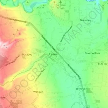
Name: Calinan topographic map, elevation, terrain.

Location: Calinan, Davao City, Davao Region, 8018, Philippines (7.15025 125.41249 7.23025 125.49249)

Average elevation: 238 m

Minimum elevation: 102 m

Maximum elevation: 455 m

Other topographic maps

Click on a map to view its topography, its elevation and its terrain.

Calinan District

Philippines > Davao City

Average elevation: 239 m

Gear up for your next adventure:

🛰️Satellite Messenger - Emergency communication for areas with no cell service
🥾Hiking Boots - Sturdy boots providing ankle support and traction on rugged trails
🍽️Titanium Camping Spork - Ultralight and indestructible eating utensil
🥽Outdoor Goggles - Protective eyewear for outdoor activities
🧢Outdoor Visor - Breathable visor for sunny hikes

As an Amazon Associate, this site earns from qualifying purchases at no extra cost to you.