
Make a donation
Gear up for your next adventure:
As an Amazon Associate, this site earns from qualifying purchases at no extra cost to you.
Güdingen topographic map
Click on the map to display elevation.
Make a donation
Gear up for your next adventure:
As an Amazon Associate, this site earns from qualifying purchases at no extra cost to you.
Güdingen
Neben dem Ensemble um die evangelische Kirche von 1778 mit einem Glockenturm aus dem 14. Jahrhundert stehen mehrere Einzelbauten unter Denkmalschutz. Auf der Höhe des Ortes befindet sich in der Saar die Staustufe Güdingen. Schleuse und Wehr wurden 1863 erbaut und stehen gemeinsam mit einem 1936 errichteten Schleusenwärterhäuschen unter Denkmalschutz.
Make a donation
Gear up for your next adventure:
As an Amazon Associate, this site earns from qualifying purchases at no extra cost to you.
About this map
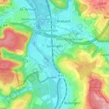
Name: Güdingen topographic map, elevation, terrain.
Average elevation: 241 m
Minimum elevation: 186 m
Maximum elevation: 352 m
Make a donation
Gear up for your next adventure:
As an Amazon Associate, this site earns from qualifying purchases at no extra cost to you.
Other topographic maps
Click on a map to view its topography, its elevation and its terrain.
Staffelberg
Deutschland > Saarland > Regionalverband Saarbrücken > Saarbrücken
Average elevation: 331 m
Großer Homburg
Deutschland > Saarland > Regionalverband Saarbrücken > Saarbrücken
Average elevation: 259 m
Neu-Aschbach
Deutschland > Saarland > Regionalverband Saarbrücken > Saarbrücken
Average elevation: 233 m
Make a donation
Gear up for your next adventure:
As an Amazon Associate, this site earns from qualifying purchases at no extra cost to you.
Pfaffenkopf
Deutschland > Saarland > Regionalverband Saarbrücken > Saarbrücken
Average elevation: 294 m