
Thank you for supporting this site ❤️
Make a donation
Make a donation
Gear up for your next adventure:
As an Amazon Associate, this site earns from qualifying purchases at no extra cost to you.
Amaguaña topographic map
Click on the map to display elevation.
Thank you for supporting this site ❤️
Make a donation
Make a donation
Gear up for your next adventure:
As an Amazon Associate, this site earns from qualifying purchases at no extra cost to you.
About this map
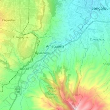
Name: Amaguaña topographic map, elevation, terrain.
Location: Amaguaña, Quito Canton, Pichincha, Ecuador (-0.45697 -78.52117 -0.31889 -78.46363)
Average elevation: 2,896 m
Minimum elevation: 2,467 m
Maximum elevation: 4,015 m
Thank you for supporting this site ❤️
Make a donation
Make a donation
Gear up for your next adventure:
As an Amazon Associate, this site earns from qualifying purchases at no extra cost to you.