
Make a donation
Gear up for your next adventure:
As an Amazon Associate, this site earns from qualifying purchases at no extra cost to you.
Nagelsberg topographic map
Click on the map to display elevation.
Make a donation
Gear up for your next adventure:
As an Amazon Associate, this site earns from qualifying purchases at no extra cost to you.
About this map
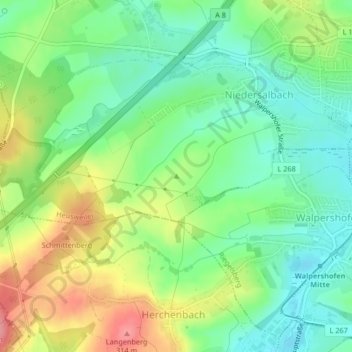
Name: Nagelsberg topographic map, elevation, terrain.
Average elevation: 252 m
Minimum elevation: 215 m
Maximum elevation: 312 m
Make a donation
Gear up for your next adventure:
As an Amazon Associate, this site earns from qualifying purchases at no extra cost to you.
Other topographic maps
Click on a map to view its topography, its elevation and its terrain.
Wahlschied
Deutschland > Saarland > Regionalverband Saarbrücken > Heusweiler
Wahlschied liegt im Saar-Nahe-Bergland, im Prims-Blies-Hügelland, am östlichen Ausläufer des oberen Köllertals, nämlich östlich der Heusweiler-Reisbacher Mulde, am Wahlbach, einem linken Nebenfluss des Köllerbaches und nördlich des Köllertaler Waldes, einem Teil des Saarkohlenwaldes, etwa einen…
Average elevation: 363 m
Make a donation
Gear up for your next adventure:
As an Amazon Associate, this site earns from qualifying purchases at no extra cost to you.
Wahlschied
Deutschland > Saarland > Regionalverband Saarbrücken > Heusweiler
Wahlschied liegt im Saar-Nahe-Bergland, im Prims-Blies-Hügelland, am östlichen Ausläufer des oberen Köllertals, nämlich östlich der Heusweiler-Reisbacher Mulde, am Wahlbach, einem linken Nebenfluss des Köllerbaches und nördlich des Köllertaler Waldes, einem Teil des Saarkohlenwaldes, etwa einen…
Average elevation: 363 m