
Make a donation
Gear up for your next adventure:
As an Amazon Associate, this site earns from qualifying purchases at no extra cost to you.
Pragser Wildsee - Lago di Braies topographic map
Click on the map to display elevation.
Make a donation
Gear up for your next adventure:
As an Amazon Associate, this site earns from qualifying purchases at no extra cost to you.
About this map
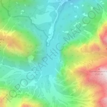
Name: Pragser Wildsee - Lago di Braies topographic map, elevation, terrain.
Average elevation: 1,744 m
Minimum elevation: 1,425 m
Maximum elevation: 2,444 m
Make a donation
Gear up for your next adventure:
As an Amazon Associate, this site earns from qualifying purchases at no extra cost to you.
Other topographic maps
Click on a map to view its topography, its elevation and its terrain.
Schmieden - Ferrara
Italy > Trentino – Alto Adige/Südtirol > South Tyrol > Prags - Braies
Average elevation: 1,426 m
Kühwiesenkopf - Monte Prà della Vacca
Italy > Trentino – Alto Adige/Südtirol > South Tyrol > Prags - Braies
Average elevation: 1,854 m
Croda del Becco - Sas dla Porta - Seekofel
Italy > Trentino – Alto Adige/Südtirol > South Tyrol > Prags - Braies
Average elevation: 2,186 m