Geolocate

Senise topographic map

Click on the map to display elevation.

About this map

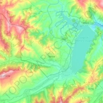
Name: Senise topographic map, elevation, terrain.

Location: Senise, Potenza, Basilicata, 85038, Italy (40.09113 16.24103 40.21489 16.38436)

Average elevation: 378 m

Minimum elevation: 187 m

Maximum elevation: 768 m

Other topographic maps

Click on a map to view its topography, its elevation and its terrain.

Viadotto Pantanelle

Italy > Basilicata > Potenza > Nemoli

Average elevation: 1,685 m

Gear up for your next adventure:

🔥Emergency Fire Starter - Reliable ignition source for all weather conditions
Bushcraft Tarp - Versatile emergency shelter or gear protection
🧢Beanie Hat - Keep your head warm in cold weather
🥾Hiking Shorts - Breathable shorts suitable for summer hikes
👟Sport Hiking Sandals - Breathable footwear for water crossings and camp rest

As an Amazon Associate, this site earns from qualifying purchases at no extra cost to you.