Geolocate

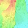
Trecate topographic map

Click on the map to display elevation.

About this map

Name: Trecate topographic map, elevation, terrain.

Location: Trecate, Novara, Piemonte, 28069, Italia (45.39797 8.66888 45.46599 8.81198)

Average elevation: 134 m

Minimum elevation: 104 m

Maximum elevation: 160 m

Other topographic maps

Click on a map to view its topography, its elevation and its terrain.

Coiromonte

Italia > Piemonte > Novara

Average elevation: 739 m

Fosseno

Italia > Piemonte > Novara

Average elevation: 548 m

Gaggiolo

Italia > Piemonte > Novara

Average elevation: 211 m

Tabarino

Italia > Piemonte > Novara

Average elevation: 555 m

Gear up for your next adventure:

🥾Trail Hiking Socks - Comfortable socks to prevent blisters and fatigue
🥾Hiking Shorts - Breathable shorts suitable for summer hikes
🦯Trekking Poles - Reduced impact on joints for steep topographic climbs
🧢Sun Hat - Wide-brim hat for sun protection
🧰Survival Kit - Essential gear for emergencies in the wilderness

As an Amazon Associate, this site earns from qualifying purchases at no extra cost to you.