Geolocate

Culan topographic map

Click on the map to display elevation.

About this map

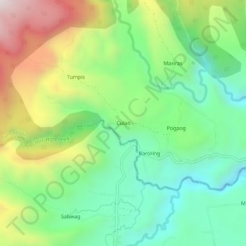
Name: Culan topographic map, elevation, terrain.

Location: Culan, Santa Cruz, Davao del Sur, Davao Region, Philippines (6.94001 125.29647 6.98001 125.33647)

Average elevation: 1,271 m

Minimum elevation: 950 m

Maximum elevation: 1,828 m

Other topographic maps

Click on a map to view its topography, its elevation and its terrain.

Tagabuli Bay

Philippines > Davao del Sur > Santa Cruz > Tagabuli > Batang

Average elevation: 28 m

Gear up for your next adventure:

🗺️Topographic Maps - Detailed maps to explore trails, mountains, and wilderness areas
🦟Insect Repellent - Keep mosquitoes and black flies away in wooded areas
🥾Waterproof Hiking Shoes - Durable shoes for wet and rugged trails
💡Compact LED Flashlight - Powerful and portable flashlight for outdoor use
Camping Groundsheet - Protect your tent from moisture and dirt

As an Amazon Associate, this site earns from qualifying purchases at no extra cost to you.