
Grover Beach topographic map
Click on the map to display elevation.
About this map
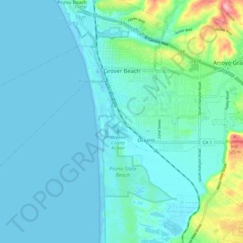
Name: Grover Beach topographic map, elevation, terrain.
Average elevation: 21 m
Minimum elevation: -1 m
Maximum elevation: 139 m
Other topographic maps
Click on a map to view its topography, its elevation and its terrain.
Avila Beach
United States > California > San Luis Obispo County
The beach is less than 0.5 miles (0.8 km) long and sheltered in San Luis Bay, which is formed by Point San Luis on the west and Fossil Point on the east. Avila Beach faces south and the 600 foot elevation of Point San Luis breaks the prevailing northwesterly winds. It is therefore usually warmer than the other…
Average elevation: 46 m
Laguna Hills Park
United States > California > San Luis Obispo County > San Luis Obispo
Average elevation: 82 m
Guadalupe-Nipomo Dunes National Wildlife Refuge
United States > California > San Luis Obispo County
Average elevation: 21 m
Pike Place
United States > California > San Luis Obispo County > Oceano > Halcyon
Average elevation: 25 m
Arroyo Grande
United States > California > San Luis Obispo County > Arroyo Grande > Arroyo Grande
Average elevation: 56 m