Geolocate

Rapone topographic map

Click on the map to display elevation.

About this map

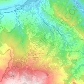
Name: Rapone topographic map, elevation, terrain.

Location: Rapone, Potenza, Basilicata, Italy (40.81795 15.46742 40.89805 15.53245)

Average elevation: 680 m

Minimum elevation: 319 m

Maximum elevation: 1,265 m

Other topographic maps

Click on a map to view its topography, its elevation and its terrain.

Viadotto Pantanelle

Italy > Basilicata > Potenza > Nemoli

Average elevation: 1,685 m

Porco Morto

Italy > Basilicata > Potenza > Picerno > Porco Morto

Average elevation: 1,071 m

Gear up for your next adventure:

🪜Heavy Duty Carabiners - Multi-use clips for securing gear to your backpack
🚲Heavy Duty Bike Lock - Secure your bike at the trailhead or during stops
🛁Quick-Dry Microfiber Towel - Space-saving towel that dries rapidly on the move
🧤Thermal Hiking Gloves - Grip-enhanced gloves for cold-weather altitude trekking
Camping Coffee Maker - Brew fresh coffee anywhere on the topographic map

As an Amazon Associate, this site earns from qualifying purchases at no extra cost to you.