
Thank you for supporting this site ❤️
Make a donation
Make a donation
Gear up for your next adventure:
As an Amazon Associate, this site earns from qualifying purchases at no extra cost to you.
Lagunas topographic map
Click on the map to display elevation.
Thank you for supporting this site ❤️
Make a donation
Make a donation
Gear up for your next adventure:
As an Amazon Associate, this site earns from qualifying purchases at no extra cost to you.
About this map
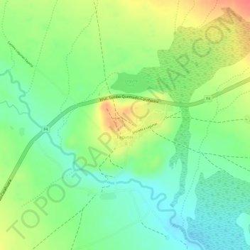
Name: Lagunas topographic map, elevation, terrain.
Average elevation: 4,135 m
Minimum elevation: 4,109 m
Maximum elevation: 4,167 m
Thank you for supporting this site ❤️
Make a donation
Make a donation
Gear up for your next adventure:
As an Amazon Associate, this site earns from qualifying purchases at no extra cost to you.
Other topographic maps
Click on a map to view its topography, its elevation and its terrain.
Ovejuyo
Bolivia > Oruro > Provincia Sajama > Municipio Curahuara de Carangas
Average elevation: 4,245 m
Nevado Sajama
Bolivia > Oruro > Provincia Sajama > Municipio Curahuara de Carangas
Average elevation: 5,801 m