
Grønning topographic map
Interactive map
Click on the map to display elevation.
About this map
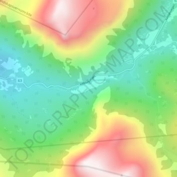
Name: Grønning topographic map, elevation, terrain.
Location: Grønning, Fjord, Møre og Romsdal, Noorwegen (62.30841 7.48949 62.34841 7.52949)
Average elevation: 665 m
Minimum elevation: 203 m
Maximum elevation: 1,461 m
Other topographic maps
Click on a map to view its topography, its elevation and its terrain.
Geiranger
Geiranger, Stranda, Møre og Romsdal, 6216, Noorwegen
Average elevation: 559 m
Eresfjord
Eresfjord, Molde, Møre og Romsdal, 6470, Noorwegen
Average elevation: 283 m
Hovdebygda
Noorwegen > Møre og Romsdal > Ørsta > Hovdebygda
Hovdebygda, Ørsta, Møre og Romsdal, 6160, Noorwegen
Average elevation: 139 m