
Antauta topographic map
Interactive map
Click on the map to display elevation.
About this map
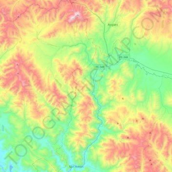
Name: Antauta topographic map, elevation, terrain.
Location: Antauta, Melgar, Puno, Peru (-14.59738 -70.49135 -14.17033 -70.26651)
Average elevation: 4,426 m
Minimum elevation: 3,917 m
Maximum elevation: 5,266 m
Other topographic maps
Click on a map to view its topography, its elevation and its terrain.
San Antonio de Putina
Peru > Puno > Quilcapuncu
San Antonio de Putina, Quilcapuncu, San Antonio de Putina, Puno, Peru
Average elevation: 4,425 m