Geolocate

Clarksburg topographic map

Click on the map to display elevation.

About this map

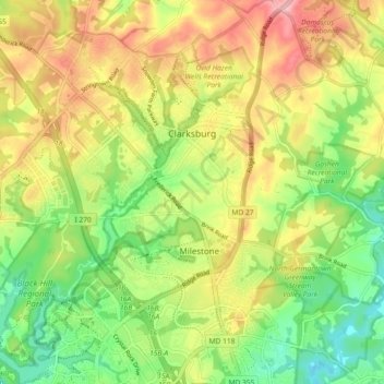
Name: Clarksburg topographic map, elevation, terrain.

Location: Clarksburg, Montgomery County, Maryland, United States (39.18392 -77.30556 39.25485 -77.21797)

Average elevation: 167 m

Minimum elevation: 98 m

Maximum elevation: 247 m

Gear up for your next adventure:

🔋Emergency Crank Radio - Weather alerts and power without needing batteries
👟Leg Gaiters - Keep debris, mud, and snow out of your boots
🛶Kayak Dry Bag - Waterproof storage for kayaking adventures
👟Sport Hiking Sandals - Breathable footwear for water crossings and camp rest
🧥Waterproof Hiking Jacket - Protect yourself from rain and wind while hiking

As an Amazon Associate, this site earns from qualifying purchases at no extra cost to you.