Geolocate

Kulha topographic map

Click on the map to display elevation.

About this map

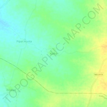
Name: Kulha topographic map, elevation, terrain.

Location: Kulha, Basoda Tahsil, Vidisha, Madhya Pradesh, India (23.72800 77.86469 23.76800 77.90469)

Average elevation: 427 m

Minimum elevation: 415 m

Maximum elevation: 441 m

Other topographic maps

Click on a map to view its topography, its elevation and its terrain.

Udaypur

India > Madhya Pradesh > Basoda Tahsil

Average elevation: 424 m

Gear up for your next adventure:

💡LED Camping Lantern - Illuminate your campsite with long-lasting lanterns
🔭Compact Binoculars - Lightweight optics for scouting trails and wildlife
💧Reusable Water Bottle - Durable water bottles for hydration on trails
🥾Hiking Gaiters - Protect legs and shoes from mud, snow, and debris
🕶️Polarized Sunglasses - Protect your eyes with durable polarized lenses

As an Amazon Associate, this site earns from qualifying purchases at no extra cost to you.