Geolocate

Maynard topographic map

Interactive map

Click on the map to display elevation.

About this map

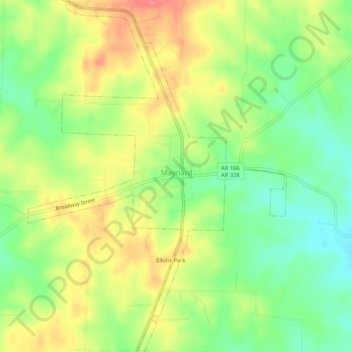
Name: Maynard topographic map, elevation, terrain.

Location: Maynard, Randolph County, Arkansas, 72444, United States (36.39879 -90.92047 36.44069 -90.88217)

Average elevation: 128 m

Minimum elevation: 94 m

Maximum elevation: 165 m

Other topographic maps

Click on a map to view its topography, its elevation and its terrain.

Sand Hill

United States > Arkansas > Randolph County > Pocahontas

Sand Hill, Pocahontas, Randolph County, Arkansas, 72455, United States

Average elevation: 118 m

Warm Springs

United States > Arkansas > Randolph County

Warm Springs, Randolph County, Arkansas, 72478, United States

Average elevation: 148 m

O'Kean

United States > Arkansas > Randolph County

O'Kean, Randolph County, Arkansas, 72425, United States

Average elevation: 82 m

Pocahontas

United States > Arkansas > Randolph County > Pocahontas

Pocahontas, Randolph County, Arkansas, United States

Average elevation: 96 m

Pocahontas

United States > Arkansas > Randolph County > Pocahontas

Pocahontas, Randolph County, Arkansas, 72455, United States

Average elevation: 94 m

O"Kean

United States > Arkansas > Randolph County > O"Kean

O"Kean, Randolph County, Arkansas, 72425, United States

Average elevation: 82 m