Geolocate

Cipondoh topographic map

Click on the map to display elevation.

About this map

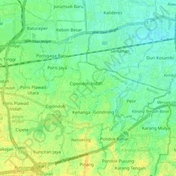
Name: Cipondoh topographic map, elevation, terrain.

Location: Cipondoh, Tangerang, Banten, Java, 15148, Indonesia (-6.20323 106.64821 -6.16364 106.72443)

Average elevation: 12 m

Minimum elevation: 2 m

Maximum elevation: 24 m

Other topographic maps

Click on a map to view its topography, its elevation and its terrain.

East Asia

Indonesia > Banten > Tangerang

Average elevation: 12 m

West Europe

Indonesia > Banten > Tangerang

Average elevation: 9 m

East Asia

Indonesia > Banten > Tangerang

Average elevation: 12 m

Gear up for your next adventure:

🛁Quick-Dry Microfiber Towel - Space-saving towel that dries rapidly on the move
Lightweight Camping Tent - Portable shelter optimized for Canadian backcountry camping
🥾Trail Running Shoes - Lightweight and durable shoes for trail running
🕶️Polarized Sunglasses - Protect your eyes with durable polarized lenses
🧤Insulated Winter Gloves - Heavy-duty protection for sub-zero Canadian adventures

As an Amazon Associate, this site earns from qualifying purchases at no extra cost to you.