Geolocate

Kerlagadec topographic map

Click on the map to display elevation.

About this map
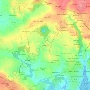
Name: Kerlagadec topographic map, elevation, terrain.

Location: Kerlagadec, Fouesnant, Quimper, Finistère, Bretagne, France métropolitaine, 29170, France (47.89829 -4.02425 47.93829 -3.98425)

Average elevation: 43 m

Minimum elevation: -1 m

Maximum elevation: 91 m

Other topographic maps

Click on a map to view its topography, its elevation and its terrain.
Île Saint-Nicolas

France > Bretagne > Finistère > Fouesnant

Average elevation: 0 m

Fort Cigogne

France > Bretagne > Finistère > Fouesnant

Average elevation: 0 m

Île de Penfret

France > Bretagne > Finistère > Fouesnant

Average elevation: 0 m

Gear up for your next adventure:

🔨Vehicle Emergency Tool - Safety tool for remote road trips to trailheads
⛺Bushcraft Tarp - Versatile emergency shelter or gear protection
🧴Bear Spray Holster - Quick-access carry for essential Canadian wilderness safety
🧴Waterproofing Spray - Restore the DWR coating on jackets and tents
🧴Outdoor Sunscreen - High SPF protection for high-altitude UV exposure

As an Amazon Associate, this site earns from qualifying purchases at no extra cost to you.