Geolocate

Kunchithanny topographic map

Click on the map to display elevation.

About this map

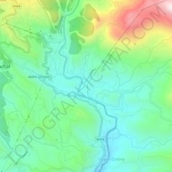
Name: Kunchithanny topographic map, elevation, terrain.

Location: Kunchithanny, Devikulam, Idukki, Kerala, India (9.99526 77.05606 10.04129 77.07937)

Average elevation: 936 m

Minimum elevation: 699 m

Maximum elevation: 1,511 m

Other topographic maps

Click on a map to view its topography, its elevation and its terrain.

Malankara Dam

India > Kerala > Idukki

Average elevation: 59 m

Muttukadu

India > Kerala > Idukki

Average elevation: 1,096 m

Mattupetty Dam

India > Kerala > Idukki

Average elevation: 1,665 m

Pettimudi Hill Top

India > Kerala > Idukki

Average elevation: 810 m

Muthirapuzha

India > Kerala > Idukki

Average elevation: 551 m

Idukki Dam

India > Kerala > Idukki

Average elevation: 701 m

Silent vally thodu

India > Kerala > Idukki

Average elevation: 1,668 m

Chokramudi

India > Kerala > Idukki

Average elevation: 1,670 m

Gear up for your next adventure:

🚲Handlebar Phone Mount - View topographic-map.com live while cycling
💡LED Camping Lantern - Illuminate your campsite with long-lasting lanterns
🥾Lightweight Hiking Boots - Boots for comfort and mobility on long hikes
🧢Sun Hat - Wide-brim hat for sun protection
🥾Trekking Poles - Adjustable trekking poles to reduce knee stress and improve stability

As an Amazon Associate, this site earns from qualifying purchases at no extra cost to you.