Geolocate

Lengatz topographic map

Click on the map to display elevation.

About this map

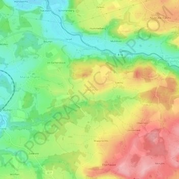
Name: Lengatz topographic map, elevation, terrain.

Location: Lengatz, Hergatz, Landkreis Lindau, Bayern, 88178, Deutschland (47.63276 9.87458 47.67276 9.91458)

Average elevation: 636 m

Minimum elevation: 568 m

Maximum elevation: 714 m

Gear up for your next adventure:

🥾Mountain Hiking Boots - High-traction boots for rocky terrain
🎒Fully Waterproof Backpack - Total protection for photography gear and electronics
🧥Packable Rain Jacket - Breathable waterproof layer for unpredictable weather
🧊Portable Cooler - Keep food and drinks cold during outdoor adventures
🧥Waterproof Pants - Keep dry during rainy hiking conditions

As an Amazon Associate, this site earns from qualifying purchases at no extra cost to you.