
Gelnica topographic map
Interactive map
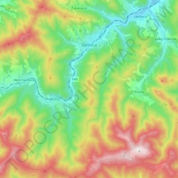
Click on the map to display elevation.
About this map
Name: Gelnica topographic map, elevation, terrain.
Average elevation: 678 m
Minimum elevation: 323 m
Maximum elevation: 1,245 m
Other topographic maps
Click on a map to view its topography, its elevation and its terrain.
Gelnica
Slovaquie > Région de Košice > okres Gelnica > Gelnica > Gelnica
Gelnica, okres Gelnica, Région de Košice, Slovaquie orientale, 056 01, Slovaquie
Average elevation: 585 m
Prakovce
Slovaquie > Région de Košice > okres Gelnica
Prakovce, okres Gelnica, Région de Košice, Slovaquie orientale, 055 62, Slovaquie
Average elevation: 692 m
Prakovce
Slovaquie > Région de Košice > okres Gelnica > Prakovce > Prakovce
Prakovce, okres Gelnica, Région de Košice, Slovaquie orientale, 055 62, Slovaquie
Average elevation: 521 m