Geolocate

Upper Lake topographic map

Click on the map to display elevation.

About this map

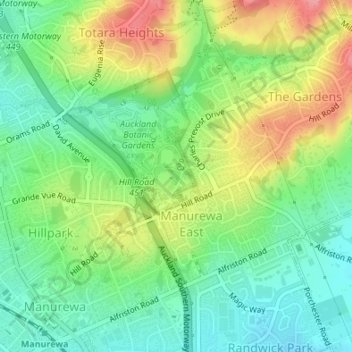
Name: Upper Lake topographic map, elevation, terrain.

Location: Upper Lake, Manurewa East, Manurewa, Auckland, New Zealand (-37.01178 174.90827 -37.01079 174.90920)

Average elevation: 57 m

Minimum elevation: 19 m

Maximum elevation: 115 m

Gear up for your next adventure:

🚲Heavy Duty Bike Lock - Secure your bike at the trailhead or during stops
🕶️Polarized Sunglasses - Protect your eyes with durable polarized lenses
🛌Down Sleeping Bag - Superior warmth-to-weight ratio for cold nights
🥾Trail Hiking Socks - Comfortable socks to prevent blisters and fatigue
🪜Heavy Duty Carabiners - Multi-use clips for securing gear to your backpack

As an Amazon Associate, this site earns from qualifying purchases at no extra cost to you.