
Timberland topographic map
Click on the map to display elevation.
About this map
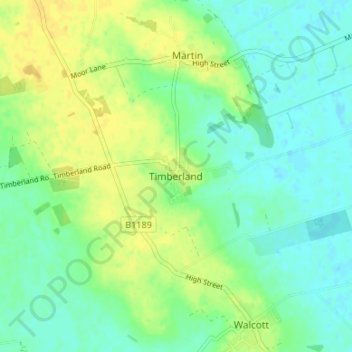
Name: Timberland topographic map, elevation, terrain.
Average elevation: 10 m
Minimum elevation: 0 m
Maximum elevation: 22 m
Other topographic maps
Click on a map to view its topography, its elevation and its terrain.
Sleaford
United Kingdom > England > Lincolnshire > North Kesteven
The town centre lies about 49 feet (15 m) above sea level and has formed around the River Slea, which runs west to north-east through it. A band of Jurassic Cornbrash limestone forms the bedrock under Holdingham (where the ground rises to 82 feet (25 m) above sea level in places), parts of central Sleaford,…
Average elevation: 18 m