
Thank you for supporting this site ❤️
Make a donation
Make a donation
Gear up for your next adventure:
As an Amazon Associate, this site earns from qualifying purchases at no extra cost to you.
Zastler-Siedlung topographic map
Click on the map to display elevation.
Thank you for supporting this site ❤️
Make a donation
Make a donation
Gear up for your next adventure:
As an Amazon Associate, this site earns from qualifying purchases at no extra cost to you.
About this map
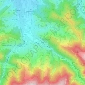
Name: Zastler-Siedlung topographic map, elevation, terrain.
Average elevation: 602 m
Minimum elevation: 396 m
Maximum elevation: 979 m
Thank you for supporting this site ❤️
Make a donation
Make a donation
Gear up for your next adventure:
As an Amazon Associate, this site earns from qualifying purchases at no extra cost to you.
Other topographic maps
Click on a map to view its topography, its elevation and its terrain.
St. Wilhelm
Deutschland > Baden-Württemberg > Landkreis Breisgau-Hochschwarzwald > Oberried
Average elevation: 1,052 m