
Brentford Ait topographic map
Interactive map
Click on the map to display elevation.
About this map
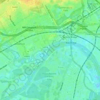
Name: Brentford Ait topographic map, elevation, terrain.
Average elevation: 11 m
Minimum elevation: 2 m
Maximum elevation: 28 m
Other topographic maps
Click on a map to view its topography, its elevation and its terrain.
Robin Hood Gardens
Reino Unido > Inglaterra > Londres
Robin Hood Gardens, Blackwall, London Borough of Tower Hamlets, Londres, Greater London, Inglaterra, Reino Unido
Average elevation: 6 m
Islington
Reino Unido > Inglaterra > Londres > Islington
Islington, Londres, Greater London, Inglaterra, N1, Reino Unido
Average elevation: 30 m
Roman Southwark
Reino Unido > Inglaterra > Londres
Roman Southwark, Clink Street, Bankside, Borough, London Borough of Southwark, Londres, Greater London, Inglaterra, SE1 9BU, Reino Unido
Average elevation: 13 m