Geolocate

Adare topographic map

Click on the map to display elevation.

About this map

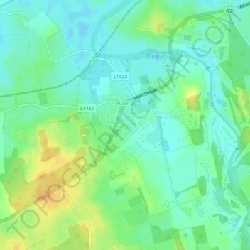
Name: Adare topographic map, elevation, terrain.

Location: Adare, The Municipal District of Adare — Rathkeale, County Limerick, Munster, Ireland (52.55386 -8.80470 52.56862 -8.78514)

Average elevation: 12 m

Minimum elevation: -1 m

Maximum elevation: 32 m

Other topographic maps

Click on a map to view its topography, its elevation and its terrain.

Gear up for your next adventure:

🎒Backpack Rain Cover - External shield to keep your entire pack dry
🧦Thermal Socks - Warm socks for winter hiking or camping
🥾Light Hiking Boots - Lightweight and comfortable boots for day hikes
🩹Moleskin Blister Pads - Direct protection for painful foot pressure points
🥾Waterproof Hiking Boots - Boots keeping your feet dry in wet conditions

As an Amazon Associate, this site earns from qualifying purchases at no extra cost to you.