Geolocate

Middlefield topographic map

Click on the map to display elevation.

About this map

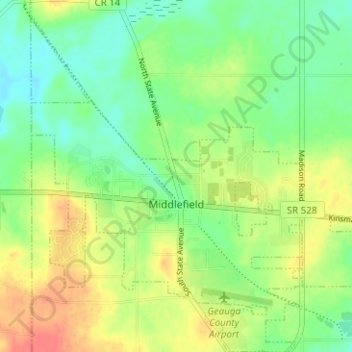
Name: Middlefield topographic map, elevation, terrain.

Location: Middlefield, Middlefield Township, Geauga County, Ohio, 44062, United States (41.44218 -81.10098 41.48921 -81.04138)

Average elevation: 351 m

Minimum elevation: 328 m

Maximum elevation: 383 m

Other topographic maps

Click on a map to view its topography, its elevation and its terrain.

Lake Aquilla

United States > Ohio > Geauga County

Average elevation: 368 m

Novelty

United States > Ohio > Geauga County

Average elevation: 337 m

Montville

United States > Ohio > Geauga County

A post office called Montville has been in operation since 1825. The area of Montville was named for its lofty elevation.

Average elevation: 370 m

Newbury

United States > Ohio > Geauga County

Average elevation: 367 m

Welshfield

United States > Ohio > Geauga County > Troy Township

Average elevation: 352 m

Little Mountain

United States > Ohio > Geauga County

Average elevation: 327 m

Eldon Russel Park

United States > Ohio > Geauga County

Average elevation: 340 m

Gear up for your next adventure:

Tent Footprint - Protect tent floor and increase durability
🥾Hiking Leggings - Comfortable leggings for outdoor activities
🧴Sunscreen SPF - Broad-spectrum sunscreen for outdoor activities
🔭Outdoor Binoculars - Lightweight binoculars for birdwatching and hiking
🥾Trail Running Shoes - Lightweight and durable shoes for trail running

As an Amazon Associate, this site earns from qualifying purchases at no extra cost to you.