Geolocate

Bautista topographic map

Click on the map to display elevation.

About this map

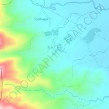
Name: Bautista topographic map, elevation, terrain.

Location: Bautista, San Pablo, Laguna, Calabarzon, 4000, Philippines (13.98106 121.25992 14.00850 121.29601)

Average elevation: 151 m

Minimum elevation: 57 m

Maximum elevation: 469 m

Other topographic maps

Click on a map to view its topography, its elevation and its terrain.

San Pablo

Philippines > Laguna > San Pablo

Average elevation: 220 m

San Buenaventura

Philippines > Laguna > San Pablo

Average elevation: 152 m

STA.77+460

Philippines > Laguna > San Pablo > San Agustin

Average elevation: 82 m

Calibato Lake

Philippines > Laguna > San Pablo > Santo Angel

Average elevation: 232 m

Santa Catalina

Philippines > Laguna > San Pablo

Average elevation: 177 m

San Roque

Philippines > Laguna > San Pablo > San Roque

Average elevation: 100 m

Mohicap Lake

Philippines > Laguna > San Pablo > Santa Catalina

Average elevation: 150 m

Mohicap Lake

Philippines > Laguna > San Pablo > Santa Catalina

Average elevation: 150 m

Calibato Lake

Philippines > Laguna > San Pablo > Santo Angel

Average elevation: 232 m

Gear up for your next adventure:

🧣Merino Neck Gaiter - Protects against wind, sun, and cold at high altitudes
🧦Outdoor Socks - Durable socks designed for hiking and outdoor sports
🥤Collapsible Travel Cup - Saves space and weight in your mess kit
👟Trail Running Shoes - Agile footwear for fast-paced topographic exploration
🛌Insulated Sleeping Pad - Critical thermal barrier between you and the cold ground

As an Amazon Associate, this site earns from qualifying purchases at no extra cost to you.