
Ninove topographic map
Interactive map
Click on the map to display elevation.
About this map
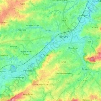
Name: Ninove topographic map, elevation, terrain.
Location: Ninove, Aalst, Flandre orientale, Belgique (50.77117 3.91806 50.87181 4.07548)
Average elevation: 36 m
Minimum elevation: 5 m
Maximum elevation: 104 m
Other topographic maps
Click on a map to view its topography, its elevation and its terrain.
Lede
Belgique > Flandre orientale > Aalst
Lede, Aalst, Flandre orientale, Flandre, 9340, Belgique
Average elevation: 17 m
Alost
Belgique > Flandre orientale > Aalst
Alost, Aalst, Flandre orientale, Flandre, Belgique
Average elevation: 20 m