Geolocate

Sophia topographic map

Click on the map to display elevation.

About this map

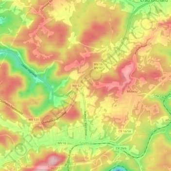
Name: Sophia topographic map, elevation, terrain.

Location: Sophia, Raleigh County, West Virginia, United States (37.70115 -81.26739 37.74063 -81.23061)

Average elevation: 742 m

Minimum elevation: 626 m

Maximum elevation: 821 m

Other topographic maps

Click on a map to view its topography, its elevation and its terrain.

Dry Hill

United States > West Virginia > Raleigh County

Average elevation: 730 m

Odd

United States > West Virginia > Raleigh County

Average elevation: 860 m

Harper

United States > West Virginia > Raleigh County

Average elevation: 693 m

Pluto

United States > West Virginia > Raleigh County

Average elevation: 867 m

Gear up for your next adventure:

🧢Sun Protection Cap - Breathable cap to protect from sun exposure
🥤Collapsible Travel Cup - Saves space and weight in your mess kit
Camping Coffee Maker - Brew fresh coffee anywhere on the topographic map
🔦LED Headlamp - Hands-free lighting for early morning starts or late finishes
🛰️Satellite Messenger - Emergency communication for areas with no cell service

As an Amazon Associate, this site earns from qualifying purchases at no extra cost to you.