Geolocate

Tauscha topographic map

Click on the map to display elevation.

About this map

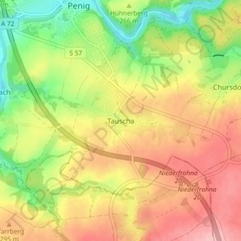
Name: Tauscha topographic map, elevation, terrain.

Location: Tauscha, Penig, Mittelsachsen, Sachsen, 09322, Deutschland (50.89399 12.69865 50.93399 12.73865)

Average elevation: 271 m

Minimum elevation: 199 m

Maximum elevation: 337 m

Other topographic maps

Click on a map to view its topography, its elevation and its terrain.

09322

Deutschland > Sachsen > Mittelsachsen > Penig > Wernsdorf

Average elevation: 254 m

Gear up for your next adventure:

🛶Waterproof Dry Bags - Keep electronics and clothes dry during river crossings
🥾Mountain Hiking Shoes - Shoes with superior grip for mountainous terrain
🗺️Topographic Maps - Detailed maps to explore trails, mountains, and wilderness areas
🧶550 Survival Paracord - Versatile utility cord for emergency repairs and rigging
🧣Evaporative Cooling Towel - Beat the heat during intense summer climbs

As an Amazon Associate, this site earns from qualifying purchases at no extra cost to you.