Geolocate

Senigallia topographic map

Click on the map to display elevation.

About this map

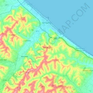
Name: Senigallia topographic map, elevation, terrain.

Location: Senigallia, Ancona, Marche, 60019, Italy (43.60431 13.11817 43.75051 13.30199)

Average elevation: 55 m

Minimum elevation: -2 m

Maximum elevation: 205 m

Other topographic maps

Click on a map to view its topography, its elevation and its terrain.

Gabriella

Italy > Marche > Ancona > Senigallia

Average elevation: 42 m

Gear up for your next adventure:

🥾Light Trekking Boots - Supportive boots for multi-day treks
🎒Fully Waterproof Backpack - Total protection for photography gear and electronics
🔭Compact Monocular - One-handed bird watching and trail spotting
🧢Sun Protection Cap - Breathable cap to protect from sun exposure
🧶550 Survival Paracord - Versatile utility cord for emergency repairs and rigging

As an Amazon Associate, this site earns from qualifying purchases at no extra cost to you.