
Make a donation
Gear up for your next adventure:
As an Amazon Associate, this site earns from qualifying purchases at no extra cost to you.
Square Roger Jourdain topographic map
Click on the map to display elevation.
Make a donation
Gear up for your next adventure:
As an Amazon Associate, this site earns from qualifying purchases at no extra cost to you.
About this map
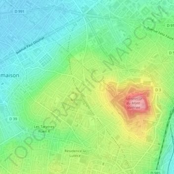
Name: Square Roger Jourdain topographic map, elevation, terrain.
Average elevation: 77 m
Minimum elevation: 29 m
Maximum elevation: 166 m
Make a donation
Gear up for your next adventure:
As an Amazon Associate, this site earns from qualifying purchases at no extra cost to you.
Other topographic maps
Click on a map to view its topography, its elevation and its terrain.
Village Mont-Valérien
France > Île-de-France > Hauts-de-Seine > Rueil-Malmaison
Average elevation: 84 m
Résidence Castellina
France > Île-de-France > Hauts-de-Seine > Rueil-Malmaison
Average elevation: 50 m
Make a donation
Gear up for your next adventure:
As an Amazon Associate, this site earns from qualifying purchases at no extra cost to you.