Geolocate

Basruru topographic map

Click on the map to display elevation.

About this map

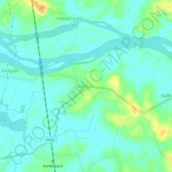
Name: Basruru topographic map, elevation, terrain.

Location: Basruru, Kundapura, Udupi District, Karnataka, 576211, India (13.61083 74.71668 13.65083 74.75668)

Average elevation: 11 m

Minimum elevation: 1 m

Maximum elevation: 39 m

Other topographic maps

Click on a map to view its topography, its elevation and its terrain.

Koni

India > Karnataka > Kundapura

Average elevation: 12 m

Ulluru

India > Karnataka > Kundapura

Average elevation: 52 m

Kalawara

India > Karnataka > Kundapura > Kalavara

Average elevation: 19 m

Koni

India > Karnataka > Kundapura > Koni

Average elevation: 12 m

Gear up for your next adventure:

🥾Approach Boots - Comfortable boots for hiking and climbing approaches
🗺️Topographic Maps - Detailed maps to explore trails, mountains, and wilderness areas
💧Hydration Pack - Hands-free hydration system for long hikes
🦌Outdoor Trail Camera - Monitor wildlife activity near your favorite spots
🔦LED Headtorch - Bright and durable light for night activities

As an Amazon Associate, this site earns from qualifying purchases at no extra cost to you.