Geolocate

Herman topographic map

Click on the map to display elevation.

About this map

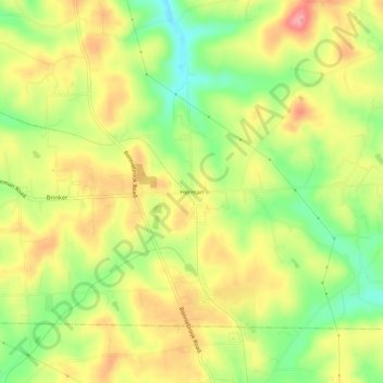
Name: Herman topographic map, elevation, terrain.

Location: Herman, Summit Township, Butler County, Pennsylvania, 16039, United States (40.81006 -79.83116 40.85006 -79.79116)

Average elevation: 390 m

Minimum elevation: 334 m

Maximum elevation: 442 m

Other topographic maps

Click on a map to view its topography, its elevation and its terrain.

Meadowood

United States > Pennsylvania > Butler County

Average elevation: 355 m

Chicora

United States > Pennsylvania > Butler County

Average elevation: 385 m

Bruin

United States > Pennsylvania > Butler County

Average elevation: 383 m

Callery

United States > Pennsylvania > Butler County

Average elevation: 321 m

Eau Claire

United States > Pennsylvania > Butler County

Average elevation: 444 m

Fairview

United States > Pennsylvania > Butler County

Average elevation: 412 m

Karns City

United States > Pennsylvania > Butler County

Average elevation: 404 m

Petrolia

United States > Pennsylvania > Butler County

Average elevation: 405 m

Valencia

United States > Pennsylvania > Butler County

Average elevation: 351 m

Gear up for your next adventure:

👟Leg Gaiters - Keep debris, mud, and snow out of your boots
🧢Beanie Hat - Keep your head warm in cold weather
💡Portable Camping Lamp - Rechargeable lamp for campsite lighting
🥾Trail Hiking Shoes - Durable shoes designed for rugged trails
🔥Emergency Fire Starter - Reliable ignition source for all weather conditions

As an Amazon Associate, this site earns from qualifying purchases at no extra cost to you.