
Lester Beach topographic map
Interactive map
Click on the map to display elevation.
About this map
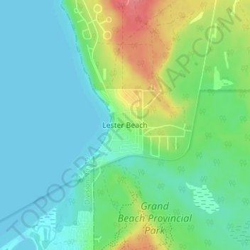
Name: Lester Beach topographic map, elevation, terrain.
Average elevation: 233 m
Minimum elevation: 215 m
Maximum elevation: 281 m
Other topographic maps
Click on a map to view its topography, its elevation and its terrain.
Albert Beach
Canada > Manitoba > Division No 1 > Municipalité rurale d'Alexander
Albert Beach, Municipalité rurale d'Alexander, Division No 1, Manitoba, R0E 2C0, Canada
Average elevation: 223 m