Geolocate

Alban topographic map

Click on the map to display elevation.

About this map

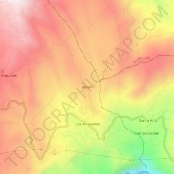
Name: Alban topographic map, elevation, terrain.

Location: Alban, Túquerres, La Sabana, Nariño, RAP Pacífico, Colombia (1.07151 -77.59268 1.11151 -77.55268)

Average elevation: 2,922 m

Minimum elevation: 2,436 m

Maximum elevation: 3,217 m

Gear up for your next adventure:

🔋Emergency Crank Radio - Weather alerts and power without needing batteries
🥾Mountaineering Boots - Supportive boots for climbing and high-altitude hiking
🔨Vehicle Emergency Tool - Safety tool for remote road trips to trailheads
🧳Compression Sacks - Maximize space in your backpack by shrinking gear
🧥Insulated Jacket - Keep warm in cold outdoor conditions

As an Amazon Associate, this site earns from qualifying purchases at no extra cost to you.