Geolocate

Bethlehem topographic map

Click on the map to display elevation.

Bethlehem

Bethlehem is located at an elevation of about 775 meters (2,543 ft) above sea level, 30 meters (98 ft) higher than nearby Jerusalem. Bethlehem is situated on the Judean Mountains.

Wikipedia (CC-BY-SA 3.0)

About this map

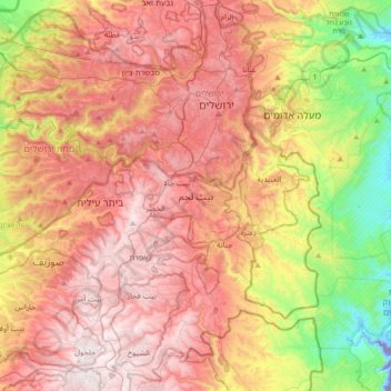
Name: Bethlehem topographic map, elevation, terrain.

Location: Bethlehem, Area A, West Bank, Palestinian Territories (31.54436 35.04619 31.86436 35.36619)

Average elevation: 553 m

Minimum elevation: -228 m

Maximum elevation: 1,019 m

Gear up for your next adventure:

🥾Trekking Boots - Durable boots for long-distance trekking
🕶️Polarized Sunglasses - Protect your eyes with durable polarized lenses
Camping Coffee Maker - Brew fresh coffee anywhere on the topographic map
🥾Trail Hiking Shoes - Durable shoes designed for rugged trails
🥾Trail Running Shoes - Lightweight and durable shoes for trail running

As an Amazon Associate, this site earns from qualifying purchases at no extra cost to you.