
Make a donation
Gear up for your next adventure:
As an Amazon Associate, this site earns from qualifying purchases at no extra cost to you.
Limestone topographic map
Click on the map to display elevation.
Make a donation
Gear up for your next adventure:
As an Amazon Associate, this site earns from qualifying purchases at no extra cost to you.
About this map
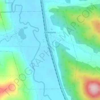
Name: Limestone topographic map, elevation, terrain.
Average elevation: 479 m
Minimum elevation: 421 m
Maximum elevation: 699 m
Make a donation
Gear up for your next adventure:
As an Amazon Associate, this site earns from qualifying purchases at no extra cost to you.
Other topographic maps
Click on a map to view its topography, its elevation and its terrain.
Farmersville Station
United States > New York > Cattaraugus County > Town of Farmersville
Average elevation: 563 m
Make a donation
Gear up for your next adventure:
As an Amazon Associate, this site earns from qualifying purchases at no extra cost to you.
Olean
United States > New York > Cattaraugus County
As a result of its higher elevation, Olean has a cooler humid continental climate (Köppen Dfb) than the larger western New York cities with hot-summer humid continental climates (Dfa).
Average elevation: 551 m
Make a donation
Gear up for your next adventure:
As an Amazon Associate, this site earns from qualifying purchases at no extra cost to you.