Geolocate

Roanoke topographic map

Click on the map to display elevation.

About this map

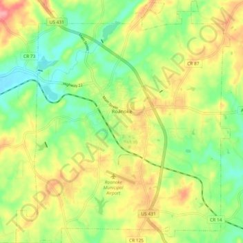
Name: Roanoke topographic map, elevation, terrain.

Location: Roanoke, Randolph County, Alabama, 36274, United States (33.10860 -85.41184 33.18588 -85.33033)

Average elevation: 252 m

Minimum elevation: 209 m

Maximum elevation: 304 m

Other topographic maps

Click on a map to view its topography, its elevation and its terrain.

Wadley

United States > Alabama > Randolph County

Average elevation: 209 m

Melody Lane

United States > Alabama > Randolph County > Roanoke

Average elevation: 262 m

Flat Rock

United States > Alabama > Randolph County

Average elevation: 253 m

High Pine

United States > Alabama > Randolph County

Average elevation: 235 m

Newell

United States > Alabama > Randolph County > Newell

Average elevation: 286 m

Woodland

United States > Alabama > Randolph County

Average elevation: 313 m

Roanoke

United States > Alabama > Randolph County > Roanoke

Average elevation: 251 m

Gear up for your next adventure:

🧊Portable Cooler - Keep food and drinks cold during outdoor adventures
🔦UV Flashlight - Detect minerals or specific insects in the dark
🦌Outdoor Trail Camera - Monitor wildlife activity near your favorite spots
🎒Hiking Daypack - Lightweight and durable backpacks for day trips and excursions
🥾Durable Hiking Shoes - Long-lasting shoes for frequent hiking

As an Amazon Associate, this site earns from qualifying purchases at no extra cost to you.