
Make a donation
Gear up for your next adventure:
As an Amazon Associate, this site earns from qualifying purchases at no extra cost to you.
Stuie topographic map
Click on the map to display elevation.
Make a donation
Gear up for your next adventure:
As an Amazon Associate, this site earns from qualifying purchases at no extra cost to you.
About this map
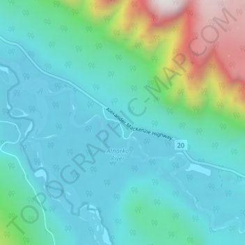
Name: Stuie topographic map, elevation, terrain.
Average elevation: 433 m
Minimum elevation: 146 m
Maximum elevation: 1,608 m
Central Coast Regional District trails, hiking, mountain biking, running and outdoor activities
Make a donation
Gear up for your next adventure:
As an Amazon Associate, this site earns from qualifying purchases at no extra cost to you.
Other topographic maps
Click on a map to view its topography, its elevation and its terrain.
Telegraph Creek
Canada > British Columbia > Central Coast Regional District > Area C (Hagensborg/Talchako/Atnarko)
Average elevation: 1,432 m
Vista Lake
Canada > British Columbia > Central Coast Regional District > Area C (Hagensborg/Talchako/Atnarko)
Average elevation: 1,159 m