Geolocate

Weinsfeld topographic map

Click on the map to display elevation.

About this map

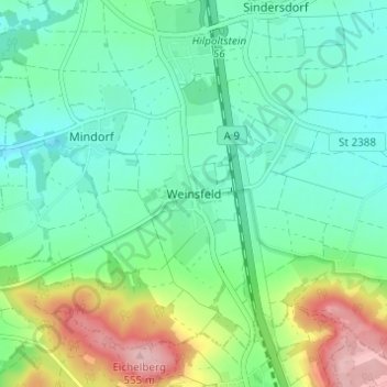
Name: Weinsfeld topographic map, elevation, terrain.

Location: Weinsfeld, Hilpoltstein, Landkreis Roth, Bayern, Deutschland (49.12480 11.24047 49.16480 11.28047)

Average elevation: 442 m

Minimum elevation: 396 m

Maximum elevation: 557 m

Other topographic maps

Click on a map to view its topography, its elevation and its terrain.

91161

Deutschland > Bayern > Landkreis Roth > Hilpoltstein > Grauwinkl

Average elevation: 438 m

Gear up for your next adventure:

🧥Packable Rain Jacket - Breathable waterproof layer for unpredictable weather
🧤Thermal Hiking Gloves - Grip-enhanced gloves for cold-weather altitude trekking
🧴First Aid Kit - Essential first aid supplies for outdoor emergencies
🔭Compact Binoculars - Lightweight optics for scouting trails and wildlife
📷Outdoor Action Camera - Capture high-elevation views and rugged adventures

As an Amazon Associate, this site earns from qualifying purchases at no extra cost to you.