
Groß Lüsewitz topographic map
Interactive map
Click on the map to display elevation.
About this map
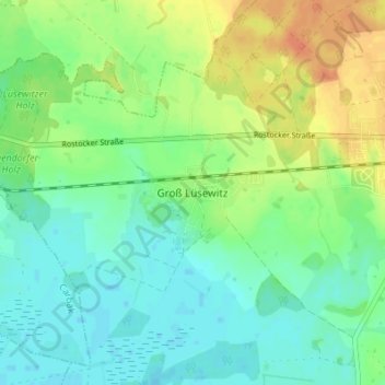
Name: Groß Lüsewitz topographic map, elevation, terrain.
Average elevation: 38 m
Minimum elevation: 24 m
Maximum elevation: 61 m
Other topographic maps
Click on a map to view its topography, its elevation and its terrain.
Gubkow
Deutschland > Mecklenburg-Vorpommern > Landkreis Rostock > Sanitz
Gubkow, Sanitz, Landkreis Rostock, Mecklenburg-Vorpommern, Deutschland
Average elevation: 40 m
Wendfeld
Deutschland > Mecklenburg-Vorpommern > Landkreis Rostock > Sanitz
Wendfeld, Sanitz, Landkreis Rostock, Mecklenburg-Vorpommern, 18190, Deutschland
Average elevation: 45 m