Geolocate

Watson topographic map

Click on the map to display elevation.

About this map

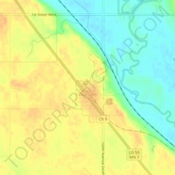
Name: Watson topographic map, elevation, terrain.

Location: Watson, Chippewa County, Minnesota, United States (45.00542 -95.80388 45.01607 -95.79567)

Average elevation: 305 m

Minimum elevation: 286 m

Maximum elevation: 320 m

Other topographic maps

Click on a map to view its topography, its elevation and its terrain.

Asbury

United States > Minnesota > Chippewa County

Average elevation: 316 m

Gear up for your next adventure:

🩹Compact First Aid Kit - Pre-packed essentials for common trail injuries
🥾Hiking Gaiters - Protect legs and shoes from mud, snow, and debris
🧦Crew Hiking Socks - Comfortable socks for long-distance hikes
🔥Camping Stove - Portable stoves to cook outdoors with ease
🛰️Satellite Messenger - Emergency communication for areas with no cell service

As an Amazon Associate, this site earns from qualifying purchases at no extra cost to you.