Geolocate

Cibolo topographic map

Click on the map to display elevation.

About this map

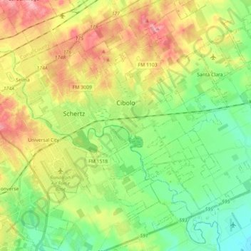
Name: Cibolo topographic map, elevation, terrain.

Location: Cibolo, Guadalupe County, Texas, 78108, United States (29.49503 -98.27420 29.61847 -98.09733)

Average elevation: 220 m

Minimum elevation: 172 m

Maximum elevation: 291 m

Other topographic maps

Click on a map to view its topography, its elevation and its terrain.

Haeckerville

United States > Texas > Guadalupe County > Cibolo

Average elevation: 213 m

Zorn

United States > Texas > Guadalupe County

Average elevation: 169 m

Gear up for your next adventure:

🧥Waterproof Jacket - Lightweight rain jackets for hiking and outdoor activities
Lightweight Camping Tent - Portable shelter optimized for Canadian backcountry camping
🔦UV Flashlight - Detect minerals or specific insects in the dark
🥾Trail Hiking Boots - Supportive boots for rough trails
🧭Orienteering Kit - Tools for map reading and navigation in the wild

As an Amazon Associate, this site earns from qualifying purchases at no extra cost to you.