
Fairfield topographic map
Click on the map to display elevation.
About this map
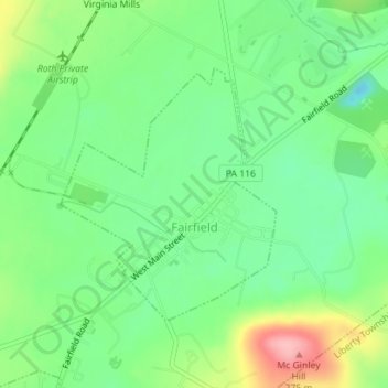
Name: Fairfield topographic map, elevation, terrain.
Location: Fairfield, Adams County, Pennsylvania, United States (39.78079 -77.38075 39.79837 -77.36119)
Average elevation: 190 m
Minimum elevation: 142 m
Maximum elevation: 275 m
Other topographic maps
Click on a map to view its topography, its elevation and its terrain.
Raven Rock Mountain
United States > Pennsylvania > Adams County > Liberty Township
Average elevation: 312 m
Gladhill (Greenstone P.O.)
United States > Pennsylvania > Adams County > Hamiltonban Township
Average elevation: 365 m