
Make a donation
Gear up for your next adventure:
As an Amazon Associate, this site earns from qualifying purchases at no extra cost to you.
Sippersfeld topographic map
Click on the map to display elevation.
Make a donation
Gear up for your next adventure:
As an Amazon Associate, this site earns from qualifying purchases at no extra cost to you.
About this map
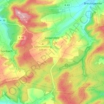
Name: Sippersfeld topographic map, elevation, terrain.
Average elevation: 322 m
Minimum elevation: 248 m
Maximum elevation: 398 m
Make a donation
Gear up for your next adventure:
As an Amazon Associate, this site earns from qualifying purchases at no extra cost to you.
Other topographic maps
Click on a map to view its topography, its elevation and its terrain.
Donnersberg
Deutschland > Rheinland-Pfalz > Donnersbergkreis > Dannenfels
Das Donnersbergmassiv hat eine Grundfläche von rund 24 km². In Nordost-Südwest-Richtung ist es zwischen Bastenhaus und Imsbach 7 km lang und in Nordwest-Südost-Richtung zwischen dem Marienthaler Mordkammerhof und dem Steinbacher Wohnplatz Haus Kaiserbusch 4,5 km breit. Sein Gipfel (686,5 m) erhebt sich 344…
Average elevation: 549 m