
Make a donation
Gear up for your next adventure:
As an Amazon Associate, this site earns from qualifying purchases at no extra cost to you.
Warren topographic map
Click on the map to display elevation.
Make a donation
Gear up for your next adventure:
As an Amazon Associate, this site earns from qualifying purchases at no extra cost to you.
Warren
From 1909 until 1970, Glencliff, located in the northern part of Warren, was the mailing address for the New Hampshire State Sanatorium, located just over the town line in Benton, at an elevation of 1,650 feet (500 m) on the slopes of Mount Moosilauke. Before the discovery of antibiotics, pure mountain air was thought to be curative for patients with tuberculosis. With its own farm on 500 acres (200 ha), the facility treated more than 4,000 individuals over its first half century, admitting between 50 and 100 per year. Many came from the industrial cities of southern New Hampshire such as Concord, Manchester and Nashua. It is now the Glencliff Home for the Elderly.
Make a donation
Gear up for your next adventure:
As an Amazon Associate, this site earns from qualifying purchases at no extra cost to you.
About this map
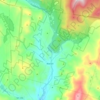
Name: Warren topographic map, elevation, terrain.
Location: Warren, Grafton County, New Hampshire, United States (43.88589 -71.96324 43.99825 -71.78977)
Average elevation: 475 m
Minimum elevation: 184 m
Maximum elevation: 1,166 m
Make a donation
Gear up for your next adventure:
As an Amazon Associate, this site earns from qualifying purchases at no extra cost to you.
Other topographic maps
Click on a map to view its topography, its elevation and its terrain.
Streeter Mountain
United States > New Hampshire > Grafton County > Dorchester
Average elevation: 449 m
Make a donation
Gear up for your next adventure:
As an Amazon Associate, this site earns from qualifying purchases at no extra cost to you.
Make a donation
Gear up for your next adventure:
As an Amazon Associate, this site earns from qualifying purchases at no extra cost to you.
The Village of Loon Mountain
United States > New Hampshire > Grafton County > Lincoln
Average elevation: 532 m
Make a donation
Gear up for your next adventure:
As an Amazon Associate, this site earns from qualifying purchases at no extra cost to you.
Make a donation
Gear up for your next adventure:
As an Amazon Associate, this site earns from qualifying purchases at no extra cost to you.
Make a donation
Gear up for your next adventure:
As an Amazon Associate, this site earns from qualifying purchases at no extra cost to you.
Stinson Lake
United States > New Hampshire > Grafton County > Rumney > Stinson Lake
Average elevation: 460 m
Make a donation
Gear up for your next adventure:
As an Amazon Associate, this site earns from qualifying purchases at no extra cost to you.
Mount Kineo, East Peak
United States > New Hampshire > Grafton County > Ellsworth
Average elevation: 710 m
LeBruns Mobile Home Park
United States > New Hampshire > Grafton County > Lebanon > LeBruns Mobile Home Park
Average elevation: 326 m
West Lebanon
United States > New Hampshire > Grafton County > Lebanon > West Lebanon
Average elevation: 165 m
Make a donation
Gear up for your next adventure:
As an Amazon Associate, this site earns from qualifying purchases at no extra cost to you.
North Littleton
United States > New Hampshire > Grafton County > Littleton > North Littleton
Average elevation: 333 m