Geolocate

Casa topographic map

Click on the map to display elevation.

About this map

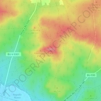
Name: Casa topographic map, elevation, terrain.

Location: Casa, Zazuar, Burgos, Castilla y León, 09491, España (41.66135 -3.55247 41.66145 -3.55237)

Average elevation: 858 m

Minimum elevation: 813 m

Maximum elevation: 907 m

Gear up for your next adventure:

Tent Footprint - Protect tent floor and increase durability
🧥Waterproof Jacket - Lightweight rain jackets for hiking and outdoor activities
Camping Coffee Maker - Brew fresh coffee anywhere on the topographic map
💧Hydration Pack - Hands-free hydration system for long hikes
🧭Orienteering Kit - Tools for map reading and navigation in the wild

As an Amazon Associate, this site earns from qualifying purchases at no extra cost to you.